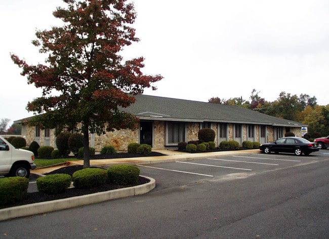
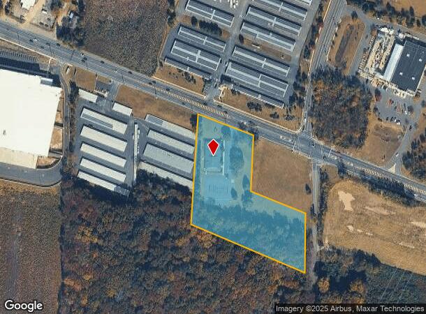
Property Record
1824 Route 38, Lumberton, NJ 08048
NEARBY LISTINGS FOR SALE OR LEASE
Property Detail
1824 Route 38
17-00022-0000-00011-03
Burlington
Officebuilding
New Jersey
X
11.3
34005C0257F
4 AC
2024
South Burlington County
2025
Philadelphia
703103
Philadelphia-Camden-Wilmington, PA-NJ-DE-MD
DEMOGRAPHICS near 1824 Route 38
1 Mile
3 Mile
5 Mile
2024 Total Population
828
29,195
52,681
2029 Population
857
29,933
53,808
Pop Growth 2024-2029
+ 3.50%
+ 2.53%
+ 2.14%
Average Age
41
40
41
2024 Total Households
335
11,217
19,977
HH Growth 2024-2029
+ 3.28%
+ 2.76%
+ 2.31%
Median Household Inc
$75,321
$81,694
$90,582
Avg Household Size
2.40
2.50
2.50
2024 Avg HH Vehicles
2.00
2.00
2.00
Median Home Value
$322,973
$278,484
$298,388
Median Year Built
1992
1977
1978
Nearby Places
Map Layers
Map Styles
 Street
 Aerial
- Restaurants
- Banks
- Shops
- Fitness
- Groceries
PUBLIC TRANSPORTATION
AIRPORT
Trenton Mercer
DRIVE
WALK
Distance
Trenton Mercer
39 min
27.0 mi
Philadelphia International
DRIVE
WALK
Distance
Philadelphia International
47 min
31.4 mi
Freight Ports
Port of Philadelphia
DRIVE
WALK
Distance
Port of Philadelphia
30 min
21.4 mi
Nearby Properties
Address
Land Use
TOTAL SIZE
Lot Size
Zoning
Address
Land Use
TOTAL SIZE
Lot Size
Zoning
3.03 AC
OB
Address
Land Use
TOTAL SIZE
Lot Size
Zoning
Address
Land Use
TOTAL SIZE
Lot Size
Zoning
27.64 AC
Address
Land Use
TOTAL SIZE
Lot Size
Zoning
53.05 AC
I2
Address
Land Use
TOTAL SIZE
Lot Size
Zoning
19.38 AC
R1
Address
Land Use
TOTAL SIZE
Lot Size
Zoning
6.59 AC
GS
Address
Land Use
TOTAL SIZE
Lot Size
Zoning
0.52 AC
GS
Address
Land Use
TOTAL SIZE
Lot Size
Zoning
Address
Land Use
TOTAL SIZE
Lot Size
Zoning
12.31 AC
Address
Land Use
TOTAL SIZE
Lot Size
Zoning
5.29 AC
TC
Address
Land Use
TOTAL SIZE
Lot Size
Zoning
12.90 AC
Address
Land Use
TOTAL SIZE
Lot Size
Zoning
20.52 AC
RH
Address
Land Use
TOTAL SIZE
Lot Size
Zoning
16.79 AC
R12
Address
Land Use
TOTAL SIZE
Lot Size
Zoning
23.33 AC
B2
Address
Land Use
TOTAL SIZE
Lot Size
Zoning
Address
Land Use
TOTAL SIZE
Lot Size
Zoning
15.60 AC
RH
Address
Land Use
TOTAL SIZE
Lot Size
Zoning
4.11 AC
Address
Land Use
TOTAL SIZE
Lot Size
Zoning
15 AC
R2
Address
Land Use
TOTAL SIZE
Lot Size
Zoning
15.64 AC
I2
Address
Land Use
TOTAL SIZE
Lot Size
Zoning
24.36 AC
Address
Land Use
TOTAL SIZE
Lot Size
Zoning
88.50 AC
MR
Address
Land Use
TOTAL SIZE
Lot Size
Zoning
Address
Land Use
TOTAL SIZE
Lot Size
Zoning
19.21 AC
R1
Address
Land Use
TOTAL SIZE
Lot Size
Zoning
20 AC
R12
Address
Land Use
TOTAL SIZE
Lot Size
Zoning
3.85 AC
R75
Address
Land Use
TOTAL SIZE
Lot Size
Zoning
35 AC
R2.5
Address
Land Use
TOTAL SIZE
Lot Size
Zoning
11.53 AC
RH
Address
Land Use
TOTAL SIZE
Lot Size
Zoning
1.34 AC
GS
Address
Land Use
TOTAL SIZE
Lot Size
Zoning
76.37 AC
Address
Land Use
TOTAL SIZE
Lot Size
Zoning
16.41 AC
The World's #1 Commercial Real Estate Marketplace
Connect with us
© 2025 CoStar Group
The information above has been obtained from sources believed reliable. While we do not doubt its accuracy we have not verified it and make no guarantee, warranty or representation about it. It is your responsibility to independently confirm its accuracy and completeness. Any projections, opinions, assumptions, or estimates used are for example only and do not represent the current or future performance of the property. The value of this transaction to you depends on tax and other factors which should be evaluated by your tax, financial, and legal advisors. You and your advisors should conduct a careful, independent investigation of the property to determine to your satisfaction the suitability of the property for your needs.